Paucarcancha is one of the lesser known archaeological sites during the famous hiking route known as the Inca Trail. Intipata is one of the most striking archaeological sites during the Inca Trail to Machu Picchu. It is located between the archaeological sites of Wiñayhuayna and Intipunku, at 2,840 meters above sea level. It stands out for the immense set of agricultural terraces located on the side of the mountain. Due to its high and difficult location, it is not easy to get there. Few tourists dare to reach this place during the third or fourth day of walking.
Performing the 4-day Inca Trail to Machu Picchu is the only way to visit important Inca archaeological sites such as: Llactapata, Runkurakay, Sayacmarca, Phuyupatamarca, Wiñayhuayna and, of course, Machupicchu. Optionally, you can make small routes to Inca sites such as Paucarcancha, Qoriwayrachina and Intipata. This last place is almost 1 kilometer from Wiwayhuayna. It can be visited, optionally, on the third day of the walk. From there you have incredible views of the entire Inca route. It draws attention for its huge and large platforms.
What is it?
Intipata is one of the many Inca archaeological sites that were built along the current hiking route known as the 4-day Inca Trail to Machu Picchu.
It is a checkpoint where different agricultural products such as potatoes, corn, oca, quinoa and even the famous coca leaf were grown on the terraces..
Its name comes from two Quechua words ‘Inti’ and ‘Pata’: the first means ‘Sun’ while the second means ‘Place or terrace’. In other words, its name means ‘Place of the sun’ or ‘Sun terrace’.
Due to its location at the top of a mountain, it also served as a control and surveillance post. From there you could see the walkers who were traveling towards the Inca city of Machu Picchu.
Where is?
Intipata is located in the Historic Sanctuary of Machu Picchu. It is also part of the circuit of archaeological sites visible during the famous 4-day Inca Trail to Machu Picchu.
It is located between the archaeological site of Wiñayhuayna and the Intipunku, the gateway to Machu Picchu. Geographically it is located 2,840 meters above sea level.
To visit Intipata it is necessary to take a hiking route of approximately 36 kilometers from kilometer 82 of the train line that connects Ollantaytambo with Aguas Calientes.
From the archaeological site of Wiñayhuayna you must walk upward for approximately 800 meters. Due to the difficulty of the ascent, it can take between 30 minutes to 1 hour approximately.
What to see
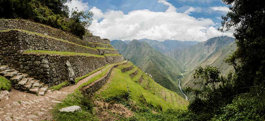
The Intipata platforms are one of the most famous scenic tourist attractions on the Inca Trail. From any part of the route you can appreciate this striking landscape of terraces attached to the edge of the mountain that forms a beautiful harmony with its surroundings.
In turn, from Intipata, you have a spectacular view of the entire Urubamba valley, with the Vilcanota river in the background.
In Intipata there is evidence of irrigation canals. Its terraces are of a considerable size (they exceed two meters high). This allowed the development of agriculture on a large scale. This place clearly demonstrates how the Incas won agricultural land even in the most inaccessible places.
The agricultural platforms of Intipata also show that they sought to avoid soil erosion. In this way, the Incas protected their most important urban centers for many centuries.
In Intipata also stand out its water channels that managed to irrigate the different levels of platforms. Its water sources have been in operation for more than five hundred years.
In the lower part of Intipata there is a triangular construction where the Incas performed religious ceremonies. A high wall stands out, one of the few well preserved, with four niches.
From Intipata you descend to the archaeological site of Wiñayhuayna. And from there, finally, a 3-kilometer hiking route is made to Machu Picchu.
More information
Intipata has a tropical and humid geography typical of the high jungle of Cusco. The climate there varies from 23ºC. in the day up to 4ºC. at night.
If the tourist spends the third night in the Wiñayhuayna camp, they have the option of visiting Intipata that same afternoon. On the other hand, if you spend the night in the Phuyupatamarca camp, it is not possible to visit it. In this case, you can only see the archaeological site from the Inca roads.
By Inca Trail Machu Picchu - Last updated, 22-08-2024
Interested in the Inca Trail? Know more about Archaeological sites!
- Huamanmarca or Wamanmarca archaeological site
- Inca Bridges on the Inca Trail
- The most important sacred temples of Machu Picchu
- Qoriwayrachina archaeological site
- Runkurakay archaeological site
- Sayacmarca archaeological site