Runkurakay is one of the Inca archaeological sites that can be observed during the Inca Trail tour to Machu Picchu. It is located in the middle of the route so it can only be visited on foot by doing this intense hiking route. It was an urban and ceremonial center. Runkurakay is 3,760 meters above sea level. The visit takes place on the third day of the walk.
Runkurakay is one of the Inca archaeological sites that the visitor will see on the 4-day Inca Trail to Machu Picchu tour. In addition, the Inca sites of: Llactapata, Sayacmarca, Phuyupatamarca and Wiñayhuayna stand out. The 4-day tour requires a 6 or 7 month advance online purchase. If you do not get availability, an option is to choose the 2-day Inca Trail tour. This route only allows you to visit the archaeological sites of Chachabamba and Wiñayhuayna. The purchase can be made 3 or 4 weeks in advance. In both cases, the route of 4 and 2 days, the final Inca site that is reached is nothing less than Machu Picchu.
Runkurakay, the abandoned site
The archaeological site of Runkurakay is an urban and religious center where the Incas controlled the passage of walkers through the historical route of qhapac ñan (royal Inca roads) that connected with Machu Picchu.
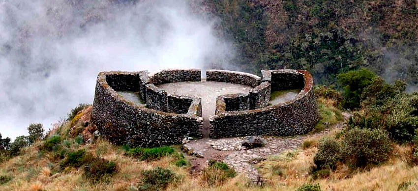
It stands out for its semi-circular buildings with incredible views of the Urubamba valley. Its name comes from two Quechua terms that mean: “abandoned house” or “collapsed house.”
Other hypotheses point out that the original name derives from the Quechua word ‘Runtu’ which means ‘Egg’. This in allusion to the egg shape of Runkurakay’s main building.
Runkurakay’s function was that of a lodging place, ‘tambo’ or control site. It is that through its constructions the ‘chasquis’ or walkers who made the route from ‘qhapac’ to Machu Picchu and the other Inca citadels located in the jungle region (Antisuyo) crossed.
In 1915 this archaeological site was also visited by the American explorer Hiram Bingham (the same one who arrived at Machu Picchu in 1911).
Runkurakay can only be visited by hiring the tour to the Inca Trail to Machu Picchu. The visit takes place in the morning of the third day.
Location
Runkurakay is located in the Historic Sanctuary of Machu Picchu (southeast of the archaeological site of Machupicchu and south of the Vilcanota River).
Geographically it is located to the south of the slope of the Runkurakay mountain. Its height reaches 3,760 meters above sea level (12,335 feet).
Runkurakay is part of the Inca trail route to Machu Picchu. It is part of the Aguas Calientes district, Urubamba province, Cusco department.
How to get there?
The only way to get to Runkurakay is via the 4-day Inca Trail to Machu Picchu. This is because the archaeological site is part of the qhapac ñan route, protected by the Peruvian State.
From the starting point of the Inca Trail, you must walk for approximately 24 kilometers. From Runkurakay you have to walk 15 kilometers to the archaeological site of Machu Picchu.
The buildings of Runkurakay
Runkurakay stands out for its semi-circular main square with scenic views of the entire Urubamba valley. Around it there are two enclosures with six entrances. Each of them has niches.
It also has enclosures, which border the construction. In the walls you can see niches or niches, as well as trapezoidal doors.
Due to its unusual shape and the presence of niches, it is presumed that important religious ceremonies were held there.
The stone used for its construction was gray granite.
More information and tips
The archaeological site of Runkurakay is surrounded by dense vegetation as it is located on the way to the extensive high jungle of Cusco. The climate varies from a minimum of 23ºC. up to a minimum of 0ºC.
Pacaymayo is the closest camp to the Inca site of Runkurakay. There tourists spend the second night of the Inca Trail route.
Runkurakay, like many of the archaeological sites on the Inca Trail, tends to dawn covered with mist in the mornings.
During your visit, do not forget to bring with you: comfortable and resistant shoes, poncho in case of rain, comfortable sports clothing, rehydrating water, cap or hat, sunscreen, trekking poles and a camera.
By Inca Trail Machu Picchu - Last updated, 22-08-2024
Interested in the Inca Trail? Know more about Archaeological sites!
- Huamanmarca or Wamanmarca archaeological site
- Inca Bridges on the Inca Trail
- The most important sacred temples of Machu Picchu
- Qoriwayrachina archaeological site
- Sayacmarca archaeological site
- Phuyupatamarca archaeological site