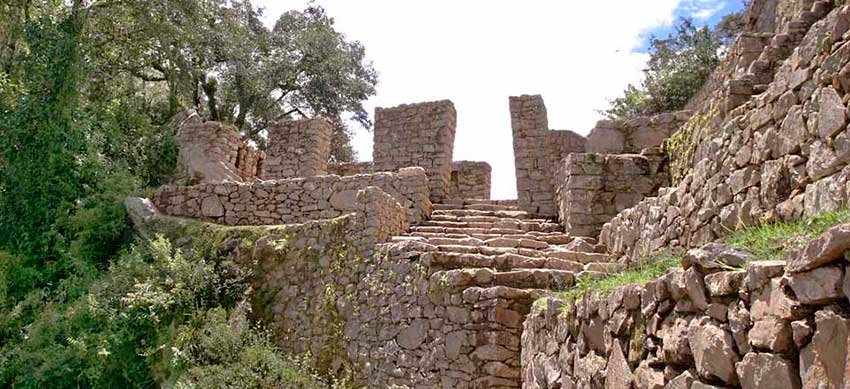
Intipunku is one of the most important constructions in Machu Picchu. It is the main door through which the Incas entered after a long walk from Cusco. Today there are only two ways to get there: from Machu Picchu through a short route of 1 hour. Or from the Inca Trail, through a 3-day route (approximately 39 kilometers). Of course, the most adventurous is this last option. The first view of Machupicchu from there is simply unforgettable.
The Intipunku was the gateway to Machu Picchu in Inca times. You got there by following the roads that the Incas built around the high mountains. Today you can also get there by following this route called ‘Inca Trail to Machu Picchu’. Another way is to take a walk from the archaeological site of Machu Picchu. Not many visitors do this route because it is not part of the classic tourist route. To go you must take an alternative path of almost 2 kilometers. Once in the Intipunku the visitor must return to Machupicchu. From there you have some of the best views of the entire place.
The Gate of the Sun of Machu Picchu
The Intipunku is the entrance gate and control center used by the Incas in Machu Picchu. Its name comes from two Quechua words that mean: ‘Sun Gate’.
Research indicates that religious ceremonies were also held there in honor of the sun, the most important Inca god. The stone constructions that are observed there show a place of importance.
From there you have a privileged panoramic view of Machu Picchu. The Incas could register the number of people who left and entered the ‘Inca city’.
The name “Intipunku” must have been put in the 20th century, responding to its location. It is that there very early, the sun makes its appearance through the same door, illuminating the entire Inca city.
Today the Intipunku serves as the gateway to Machu Picchu for tourists who do the Inca Trail, both in its 4 and 2-day versions.
Another way to visit the Intipunku is through a short walk of 2 kilometers from the current entrance gate to Machu Picchu.
Where is?
The Intipunku is located southeast of Machu Picchu, in the upper part of the archaeological site.
Its altitude reaches 2,720 meters above sea level (8,923 feet elevation).
Geographically it is located on the slopes of the Machu Picchu mountain, on the banks of the Vilcanota river.
There are only two ways to get there: with a short hiking route from Machu Picchu or with the Inca Trail (either its 4 or 2-day version).
Route through the Inca Trail
The Inca Trail to Machu Picchu lasts 4 days and covers approximately 39 kilometers. On the morning of the fourth day, after 36 kilometers of walking, we arrive at Intipunku. From the Intipunku you must descend for approximately 2 kilometers until you arrive at the archaeological site of Machu Picchu. The Inca Trail is open all year except for February.
Route through Machu Picchu
From the entrance gate to Machu Picchu you can visit the Intipunku through a hiking route of only 2 kilometers uphill. This walk can be done by any tourist as an option (it is not included in the classic tour of Machupicchu with a tour guide). In February the route remains closed to the public due to the rains.
What to see there?
The Intipunku offers one of the most impressive scenic views of Machu Picchu. When making the Inca Trail the first view that the visitor will get of Machupicchu is precisely from the Intipunku.
The constructions of the Intipunku are a sample of the Inca architectural prowess. It consists of walls, doors and windows stone. There are also niches where ceramics and gold and silver objects were housed in religious ceremonies. Every summer solstice the sun’s rays fall on its windows and walls.
Tips and more information
The Inca Trail connects Inca archaeological sites with the Intipunku and Machu Picchu. Wiñayhuayna is the closest archaeological site to Intipunku (only 3 kilometers away on foot). From the Inca site of Phuyupatamarca you must walk eleven kilometers. All these citadels were linked by the Inca roads, the Qhapac ñan.
The Intipunku can also be seen through the 2-day Inca Trail. This route only runs 12 kilometers. The starting point is kilometer 104 of the railway that connects Ollantaytambo with Aguas Calientes (on the banks of the Vilcanota river). From there you go up Inca trails until you reach Intipunku. The 2-day Inca Trail can be done with a tour organized by a Cusco travel agency.
The trek from Machu Picchu to Intipunku is a route suitable for all people. It is recommended to have a good physical condition although everyone can ascend the 2 kilometers of Inca trails to get there. Do not forget to bring: a poncho in case of rain, sunscreen, a hat, comfortable clothing and resistant shoes.
By Inca Trail Machu Picchu - Last updated, 22-08-2024
Interested in the Inca Trail? Know more about Archaeological sites!
- Huamanmarca or Wamanmarca archaeological site
- Inca Bridges on the Inca Trail
- The most important sacred temples of Machu Picchu
- Qoriwayrachina archaeological site
- Runkurakay archaeological site
- Sayacmarca archaeological site
